Extreme Ravine - Charlie (Waldo) does Mount Washington

This weekend a group of friends and I, decided to head down to New Hampshire to hike up the Tuckerman Ravine of Mount Washington for some spring snowboarding. Following the recent late April storm, we were hoping to find some good snow to shred without undue risk. Although we did find what we were looking for, we also found much more; sometimes the things you don't plan to see are what make road trips the most memorable. Best of all, now and again you even learn stuff about stuff in the process.
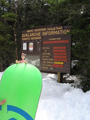
Due to the considerable avalanche danger, Charlie (Waldo) wasn't sure we should be venturing into the ravine.
The plan to go to Mount Washington had been in the works for quite some time. However, due to the effects of this year's El Niño cycle, which resulted in a much shallower than usual snowpack, we weren't sure if we would find the conditions we were hoping for. But just when we thought Ullr had completely turned his back on the north-east, we were blessed with a late season storm cycle that dumped up to 60cm of snow in 36 hours on Mount Washington. Some of you, at this point, may be thinking that 60cm of new snow in 36 hours is a clear red flag when it comes to avalanche danger, and rightly so. In fact the avalanche advisory for Tuckerman Ravine posted the danger level as “EXTREME” on Thursday, which is unusual this late in the season. In spite of this, Dana, Lindsay, Elodie, and I decided to make the trip to New Hampshire and see if we could find some terrain that would provide the right amount of fun with a tolerable amount of risk.
We left for New Hampshire on Friday evening. At this time, the avalanche danger in Tuckerman Ravine was posted as being “considerable”; an improvement over the previous day's “extreme” rating, but still more dangerous than what is generally acceptable. To make matters worse, the forecast was calling for warm weather which was expected to make the new layer of snow very cohesive and very heavy; it seemed as though April couldn't decide if it wanted to be a part of winter or summer. In spite of this, we decided to go anyway and take the chance that the snow pack would be stable enough for us to ride on Saturday.
We lazily made it to Pinkham Notch late Saturday morning. The avalanche danger was still posted at considerable for most of the Ravine (with the exception of the lower snowfields). To make matters worse, there had been recent natural avalanche activity (within the last 24 hours) in Left Gully which had run all the way to the Tuckerman Ravine trail in the bowl; another clear red flag. However, the volunteer ski patrol was there to offer advice, and their advice was to ask the Forest Service staff at Hermit Lake since they were updating the danger level hourly. So we loaded up our packs, and started up the Tuckerman Ravine trail to Hermit Lake 2200 feet (667 meters) above us. The current safe plan was to, from Hermit Lake, take the Boott Spur trail up the ridge to the summit of Boott Spur mountain and see if we could ride Hillman's Highway or Cathedral Gully from there.
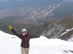
Elodie, towering over Wildcat in the background, is showing her excitement about snowboarding in May. Many people are surprised to find out that there's still enough snow for avalanches here.
On the way up, we crossed a few people who had already been riding that day so I decided to get their input on the conditions. As it turns out, Hillman's Highway was likely going to be our only option. In fact, I was told to stay away from Cathedral and the volunteer ski patrol guy at the bottom had already informed me that it was unwise to venture into the bowl (due in no small part to the recent natural avalanche activity). Armed with this new knowledge, we continued on to Hermit Lake with our sights set on Hillman's Highway, but we also revised our plan to stay away from Cathedral.
We got to the base of Hillman's Highway and Dana, Elodie, and I decided to boot pack right up the barrel of the gun (Lindsay didn't bring her snowboarding gear so she decided to head back to Pinkham). By this time this was a safe option and a much more direct route to our objective (the US Forest Service and Volunteer Ski Patrol also agreed). We left most of our extra clothes and gear at the base area – I learned last spring, a**holes don't hike this far so there were no concerns that it would be stolen – and started up the gully. It took about 45 minutes to an hour to reach the ridge line where we were exposed to pretty strong winds which chilled us significantly. For that reason, we opted to not take too long of a break at the top. We took a few photos and got our gear together to prepare for the ride down.
Although it felt cold at the top of the mountain, it was still warm enough to cause the snow to be wet and heavy. This obviously took Dana by surprise as he faceplanted to a stop no farther than 20 feet after dropping in; welcome to Tuckerman Ravine. Once we got used to the heavy, and soft, mashed potato like snow, it was much smoother sailing on the ride down. In spite of the on-going challenges in temperature control and the general fatigue, I think everyone was pretty excited to be snowboarding; I know I was.
The way down was significantly quicker than the way up since the top third of the John Sherburn ski trail was still open. This meant that we could ride part of the way down from the Hermit Lake area. However, at this point, our calves and quads were protesting quite vociferously about the excess exertion. Getting into our hiking boots for the trek out was a welcome change for weary snowboarding muscles.
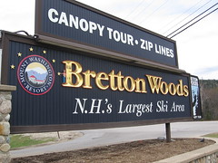
Waldo was spotted at the Mount Washington Resort where the Bretton Woods Agreement was signed in July of 1944.
The next day, we leisurely got our gear together to make the trip back to Canada. However, we decided that on the way home, we would take in a little bit of history so we stopped at Bretton Woods, the site of the Mount Washington Hotel. For those of you who slept through your high-school history classes, The Mount Washington Hotel is where the Bretton Woods Agreement was signed in July of 1944 which resulted in the establishment of the the International Monetary Fund (IMF) and the International Bank for Reconstruction and Development (IBRD), which today is part of the World Bank Group. This agreement also mandated that member countries adopt a monetary policy that maintained the exchange rate of its currency within a fixed value—plus or minus one percent—in terms of gold and the ability of the IMF to bridge temporary imbalances of payments. For better or for worse, the IMF and World Bank are important parts of today's global economy, so I thought it would be neat to actually go to the place where those institutions were effectively created. Who says mountaineers and snowboarders lack culture?
In spite of the crappy snow season leading up to it, this trip to Tuckerman Ravine turned out to be a great success. We were blessed with bluebird skies, enough snow to challenge our avalanche safety skills, and we even got some historical perspective by visiting Bretton Woods on the way home. Best of all, this was the first Mount Washington snowboarding experience for Dana, Lindsay, and Elodie who proudly wore their gnarly boots for the occasion (although though Lindsay didn't ride, I think she got a new perspective on Mount Washington nonetheless). Hopefully they're still game to wear those same gnarly boots on the May 2-4 long weekend when we hope to ride Tuckerman Ravine on the way back from surfing in Ogunquit. Although I'm pretty sure that this time around, the avalanche dangers won't be quite so extreme.

